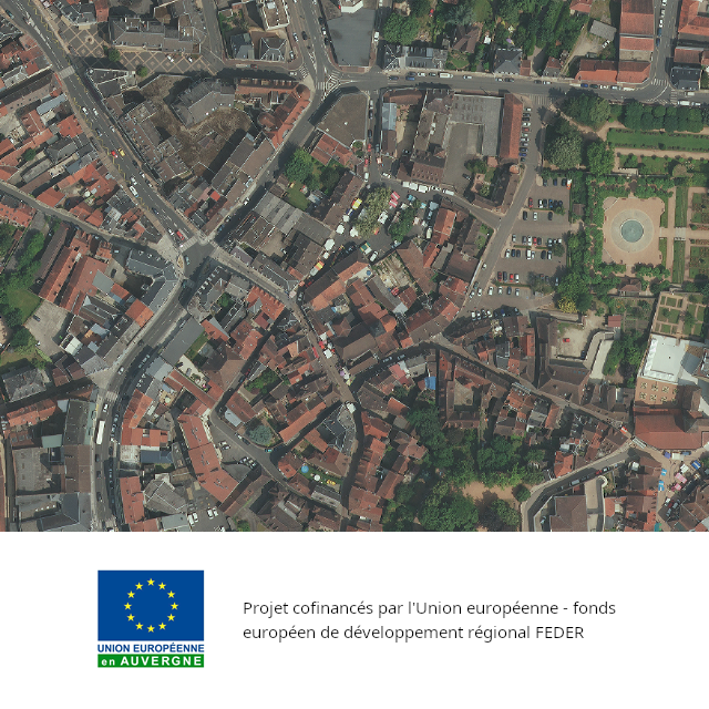
Orthophotographie couleur - Agglomération de Montluçon - PVA été 2013
Le produit Orthophotographie couleur - Agglomération de Montluçon est une orthophotographie numérique en couleurs, rectifiée dans la projection associée au système géodésique RGF93. Résolution : 0,10m - Précision planimétrique : 0,20m - Dévers < 29% - Dévers zone urbaine < 15%.
Les acquisitions ont été réalisées par le groupement d'entreprises Sintégra / APEI.
Les données sont téléchargeables en Open Data depuis le catalogue au format JPEG2000 (461 fichiers pour 11Go).
Taille et poids des données rééchantillonnées : 1jp2 - 11G.
Projet co-financé par l'Union européenne - Fonds européen de développement régional - L'Europe s'engage en Auvergne
Simple
- Alternate title
-
Base de Données Orthophotographique
- Date (Creation)
- 2013-12-31
- Date (Publication)
- 2014-04-24
- Citation identifier
- fr-130014582-montluçon2013
- Purpose
-
Le produit "Orthophotographie couleur - Agglomération de Montluçon" se compose d'images numériques (sans habillage ni surcharge) et d'indications de géoréférencement. Le contenu informationnel permet localement une utilisation jusqu'au 1 :500ième pour mettre en valeur le territoire, enrichir la visualisation des données et des projets.
- Status
- Completed
- Point of contact
-
Organisation name Individual name Electronic mail address Role Centre Régional Auvergne-Rhône-Alpes de l'Information Géographique (CRAIG)
Owner
- Maintenance and update frequency
- As needed
- Theme
-
-
orthophotoplans
-
orthophotographies
-
prises de vues aériennes
-
open data
-
données ouvertes
-
COGEO
-
- Place
-
-
Agglomération de Montluçon
-
-
COVADIS themes
-
-
REFERENTIELS - ORTHOPHOTOGRAPHIE
-
-
Communes de France
- Use limitation
-
Données ouvertes
- Access constraints
- Other restrictions
- Use constraints
- License
- Use constraints
- Other restrictions
- Other constraints
-
Licence ouverte v2.0
- Other constraints
-
Mentions obligatoires :
1- "CRAIG-SINTEGRA 2013"
2- "Projet cofinancés par l'Union européenne - fonds européen de développement régional FEDER" cette mention devra être accompagnée du logo de l'Union européenne en Auvergne
- Spatial representation type
- Grid
- Distance
- 0.1 m
- Language
- Français
- Topic category
-
- Location
- Imagery base maps earth cover
- Description
-
Agglomération de Montluçon
))
- Begin date
- 2013-07-13
- End date
- 2013-07-13
- Supplemental Information
-
Les prises de vues sont réalisées avec une caméra numérique qui assure un contenu radiométrique plus riche et plus stable. Le produit "Orthophotographie couleur - Agglomération de Montluçon" est livrable au format TIFF (Tagged Image File Format) en dalles de 0,750 km x 0,750 km, ou au format JPG2000.
- Reference system identifier
- EPSG / RGF93 / Lambert-93 (EPSG:2154) / 7.4
Spatial representation info
- Distribution format
-
Name Version JPG2000
1.0
- Units of distribution
-
Agglomération de Montluçon
- OnLine resource
-
Protocol Linkage Name WWW:LINK-1.0-http--link
https://www.craig.fr Site internet du CRAIG
WWW:LINK-1.0-http--link
https://www.etalab.gouv.fr/wp-content/uploads/2017/04/ETALAB-Licence-Ouverte-v2.0.pdf Licence Ouverte v2.0
WWW:LINK-1.0-http--link
https://www.craig.fr/opendata Informations sur les données en Open Data
WWW:DOWNLOAD-1.0-http--download
https://drive.opendata.craig.fr/s/opendata?path=%2Fortho%2F2013_montlucon_10cm Drive Opendata du CRAIG
OGC:WMS
https://tiles.craig.fr/ortho/service ortho_2013
OGC:WMTS
https://tiles.craig.fr/ortho/service ortho_2013
OGC:COG
https://cogeo.craig.fr/ortho/craig/orthocraig10_montlucon_2013.cog.tif Orthophotographie Agglomération Montluçon 2013
- Hierarchy level
- Dataset
Conformance result
- Date (Publication)
- 2010-12-08
- Explanation
-
Degré de conformité de la ressource par rapport aux spécifications visées d'Inspire (Conforme, Non Conforme, Non Evalué)
- Pass
- Oui
- Statement
-
Produit par le groupement d'entreprises APEI-SINTEGRA pour le Centre Régional Auvergnat de l'Information Géographique (CRAIG)
Métadonnées
- File identifier
- 16cc6d24-c88c-43e9-b72d-df2456c8bbd3 XML
- Metadata language
- Français
- Character set
- UTF8
- Parent identifier
-
Orthophotographie couleur - Auvergne - 2013
8cabc987-829c-4c9f-943b-6a0e255cd738
- Hierarchy level
- Dataset
- Date stamp
- 2026-06-11T14:38:34.849593423Z
- Metadata standard name
-
ISO 19115
- Metadata standard version
-
2003 Cor.1:2006
- Metadata author
-
Organisation name Individual name Electronic mail address Role Centre Régional Auvergne-Rhône-Alpes de l'Information Géographique (CRAIG)
Point of contact
Aperçus
Étendue spatiale
Fourni par
