Occupation du sol - SCoT du Bassin d'Aurillac, du Carladès et de la Châtaigneraie - 2010
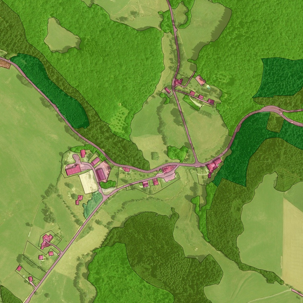
Base de données de l'occupation du sol millésime 2010 en projection Lambert-93 sur le territoire du SCoT du Bassin d'Aurillac, du Carladès et de la Châtaigneraie (1805 km²). La zone comprend Aurillac Agglomération, Carladès Communauté et la CC de la Châtaigneraie Cantalienne.
Elle se présente sous la forme d'une couche vectorielle de polygones, représentant l'occupation du sol avec en attribut la couverture (CS) et l'usage (US). Les données sont entièrement compatibles avec le produit OCS GE de l'IGN dont elles reprennent l'ossature et la nomenclature.
La base est fournie découpée par EPCI au format GeoPackage et Shapefile.
Données produites par CLS à partir de l'orthophotographie 2010 du Cantal et des bases de données de l'IGN (BD TOPO, etc.).
Simple
- Date (Creation)
- 2026-03
- Date (Publication)
- 2026-03-30
- Citation identifier
- http://www.craig.fr/ocsol_scot_bacc_2010
- Presentation form
- Digital map
- Purpose
-
Suivi de l'artificialisation des sols, planification urbaine, suivi SCoT, etc.
- Status
- Completed
- Point of contact
-
Organisation name Individual name Electronic mail address Role Centre Régional Auvergne-Rhône-Alpes de l'Information Géographique (CRAIG)
Owner Aurillac Agglomération
User
- Maintenance and update frequency
- Not planned
- Place
-
-
Aurillac Agglomération
-
CA Bassin d'Aurillac
-
CC de la Châtaigneraie Cantalienne
-
Carladès Communauté
-
CC Cère et Goul en Carladès
-
Arpajon-sur-Cère
-
Aurillac
-
Maurs
-
Saint-Mamet-la-Salvetat
-
Vic-sur-Cère
-
- Theme
-
-
open data
-
données ouvertes
-
OCS
-
OCSOL
-
OCS GE
-
occupation du sol
-
couverture du sol
-
usage du sol
-
-
COVADIS themes
-
-
FONCIER SOL - OCCUPATION SOL
-
-
Régions et départements d'Auvergne-Rhône-Alpes
-
-
Cantal
-
- Use limitation
-
Utilisation libre sous réserve de mentionner la source (a minima le nom du producteur) et la date de sa dernière mise à jour
- Access constraints
- Other restrictions
- Use constraints
- License
- Use constraints
- Other restrictions
- Other constraints
-
Licence Ouverte v2.0
- Other constraints
-
https://www.etalab.gouv.fr/wp-content/uploads/2017/04/ETALAB-Licence-Ouverte-v2.0.pdf
- Other constraints
-
Mentions obligatoires : "CRAIG - 2026"
- Spatial representation type
- Vector
- Denominator
- 5000
- Language
-
fre
- Character set
- UTF8
- Topic category
-
- Imagery base maps earth cover
- Farming
- Environment
))
- Unique resource identifier
- EPSG:2154
- Topology level
- Full surface graph
- Geometric object type
- Surface
- Distribution format
-
Name Version GeoPackage
ESRI Shapefile
1.0
- OnLine resource
-
Protocol Linkage Name WWW:LINK-1.0-http--link
https://drive.opendata.craig.fr/s/opendata?path=%2Focsol%2F2010_scot_bacc 2010_scot_bacc
WWW:DOWNLOAD-1.0-http--download https://ids.craig.fr/geocat/srv/api/records/63e37a05-0568-4be3-8fb9-267574eed8de/attachments/Style_OCS_GE_couverture_sol.qml Style_OCS_GE_couverture_sol.qml
WWW:DOWNLOAD-1.0-http--download https://ids.craig.fr/geocat/srv/api/records/63e37a05-0568-4be3-8fb9-267574eed8de/attachments/Style_OCS_GE_usage_sol.qml Style_OCS_GE_usage_sol.qml
OGC:WMS
http://ids.craig.fr/wxs/public/wms ocsol_scot_bacc_2010_couverture
OGC:WMS
http://ids.craig.fr/wxs/public/wms ocsol_scot_bacc_2010_usage
- Hierarchy level
- Dataset
Conformance result
- Date (Publication)
- 2013-10-21
- Explanation
-
Non évalué
- Pass
- Non
- Statement
-
Produit par CLS pour le Centre Régional Auvergne-Rhône-Alpes de l'Information Géographique (CRAIG).
Les données ont été produites à la demande d'Aurillac Agglomération et du SCoT BACC afin notamment étudier les changements d'occupation sur la période 2010-2020.
Métadonnées
- File identifier
- 63e37a05-0568-4be3-8fb9-267574eed8de XML
- Metadata language
-
fre
- Character set
- UTF8
- Hierarchy level
- Dataset
- Date stamp
- 2026-04-01T06:38:38.717164865Z
- Metadata standard name
-
ISO 19115:2003/19139
- Metadata standard version
-
1.0
- Metadata author
-
Organisation name Individual name Electronic mail address Role Centre Régional Auvergne-Rhône-Alpes de l'Information Géographique (CRAIG)
Point of contact
Aperçus
Étendue spatiale
Fourni par
