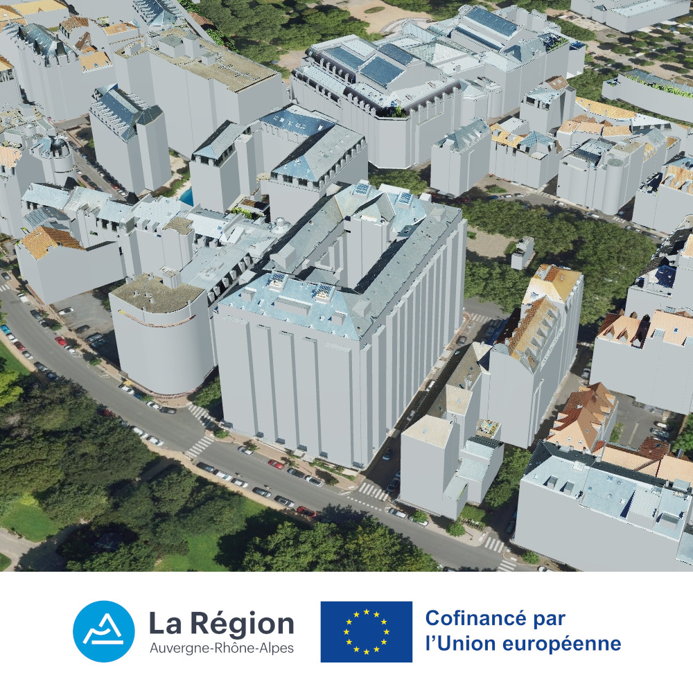
Maquette 3D / périmètre UNESCO - Vichy - 2024
Maquette numérique 3D de bâtiments en projection Lambert-93 / NGF-IGN69 sur le périmètre inscrit au Patrimoine Mondial de l'UNESCO de la ville de Vichy.
Les données sont fournies aux formats CityGML et CityJSON.
Elles sont constituées de 879 bâtiments sous forme de modèles 3D texturés sur la toiture en LoD 3.
Leur production a été réalisée en 2024 par ATGT à partir de PVA nadirales à 3 cm de résolution acquises en 2021. Leur précision est inférieure à 10 cm en planimétrie (XY) et à 20 cm en altimétrie (Z).
Cette opération a été cofinancée par l’Union européenne dans le cadre du programme FEDER.
Simple
- Date (Creation)
- 2024-12
- Citation identifier
- http://www.craig.fr/bati3d_vichy_unesco_2024
- Presentation form
- Digital model
- Status
- Completed
- Point of contact
-
Organisation name Individual name Electronic mail address Role Centre Régional Auvergne-Rhône-Alpes de l'Information Géographique (CRAIG)
Owner Centre Régional Auvergne-Rhône-Alpes de l'Information Géographique (CRAIG)
Point of contact
- Maintenance and update frequency
- Not planned
- Metadata author
-
Organisation name Individual name Electronic mail address Role Centre Régional Auvergne-Rhône-Alpes de l'Information Géographique (CRAIG)
Point of contact
- Theme
-
-
3D
-
bâtiments
-
bati3d
-
maquette numérique
-
CIM
-
city information modeling
-
open data
-
données ouvertes
-
UNESCO
-
-
Régions et départements d'Auvergne-Rhône-Alpes
-
-
Auvergne-Rhône-Alpes
-
Allier
-
-
GEMET - INSPIRE themes, version 1.0
-
-
Bâtiments
-
- Place
-
-
Vichy
-
- Use limitation
-
Utilisation libre sous réserve de mentionner la source (a minima le nom du producteur) et la date de sa dernière mise à jour
- Access constraints
- Other restrictions
- Use constraints
- License
- Use constraints
- Other restrictions
- Other constraints
-
Licence Ouverte v2.0
- Other constraints
-
https://www.etalab.gouv.fr/wp-content/uploads/2017/04/ETALAB-Licence-Ouverte-v2.0.pdf
- Other constraints
-
Mentions obligatoires : "CRAIG - FEDER Auvergne-Rhône-Alpes - 2025"
- Spatial representation type
- Vector
- Denominator
- 100
- Language
-
fre
- Character set
- UTF8
- Topic category
-
- Elevation
- Planning cadastre
))
- Topology level
- Topology 3D
- Geometric object type
- Solid
- Distribution format
-
Name Version CityGML
CityJSON
COLLADA
ESRI Geodatabase
OBJ
- OnLine resource
-
Protocol Linkage Name WWW:DOWNLOAD:CityGML
https://drive.opendata.craig.fr/s/opendata?path=%2F3d%2Fbati3d%2F02_CIM%2FCityGML%2F2024_Building%2FVichy_UNESCO 02_CIM/CityGML
WWW:DOWNLOAD:CityJSON
https://drive.opendata.craig.fr/s/opendata?path=%2F3d%2Fbati3d%2F02_CIM%2FCityJSON%2F2024_Building%2FVichy_UNESCO 02_CIM/CityJSON
WWW:LINK-1.0-http--link
https://www.vichy-patrimoine-mondial.com/situer/ Le périmètre du site patrimoine mondial à Vichy
OGC:3DTILES
https://3d.craig.fr/datasets/bati3d_aura/03_vichy_communaute/2024_building/tileset.json Vichy - bâti 3D 2024
- Hierarchy level
- Dataset
- Statement
-
Produit par ATGT pour le Centre Régional Auvergne-Rhône-Alpes de l'Information Géographique (CRAIG)
Les bâtiments ont été tracés en photogrammétrie sur des PVA nadirales à 3 cm de résolution.
Métadonnées
- File identifier
- ce6d5788-f1af-43de-bfd3-6fd7c9010676 XML
- Metadata language
-
fre
- Character set
- UTF8
- Parent identifier
-
Modélisation 3D de bâtiments - Auvergne-Rhône-Alpes - 2024-2025
c56c8297-a039-4a51-ab63-b804954b0538
- Hierarchy level
- Dataset
- Date stamp
- 2025-06-27T14:08:15.732100603Z
- Metadata standard name
-
ISO 19115:2003/19139
- Metadata standard version
-
1.0
- Metadata author
-
Organisation name Individual name Electronic mail address Role Centre Régional Auvergne-Rhône-Alpes de l'Information Géographique (CRAIG)
Point of contact
Aperçus
Étendue spatiale
Fourni par
